![Item #CL206-6 [Japanese Historical Atlas Of China]. Sekisui Nagakubo, 1717–1801 Japanese.](https://joseflebovicgallery.cdn.bibliopolis.com/pictures/CL206-6_1.jpg?width=768&height=1000&fit=bounds&auto=webp&v=1667356455)
![[Japanese Historical Atlas Of China]](https://joseflebovicgallery.cdn.bibliopolis.com/pictures/CL206-6_10.jpg?auto=webp&v=1667356455)
![[Japanese Historical Atlas Of China]](https://joseflebovicgallery.cdn.bibliopolis.com/pictures/CL206-6_11.jpg?auto=webp&v=1667356455)
![[Japanese Historical Atlas Of China]](https://joseflebovicgallery.cdn.bibliopolis.com/pictures/CL206-6_12.jpg?auto=webp&v=1667356455)
![[Japanese Historical Atlas Of China]](https://joseflebovicgallery.cdn.bibliopolis.com/pictures/CL206-6_13.jpg?auto=webp&v=1667356455)
![[Japanese Historical Atlas Of China]](https://joseflebovicgallery.cdn.bibliopolis.com/pictures/CL206-6_14.jpg?auto=webp&v=1667356455)
![[Japanese Historical Atlas Of China]](https://joseflebovicgallery.cdn.bibliopolis.com/pictures/CL206-6_2.jpg?auto=webp&v=1667356455)
![[Japanese Historical Atlas Of China]](https://joseflebovicgallery.cdn.bibliopolis.com/pictures/CL206-6_3.jpg?auto=webp&v=1667356455)
![[Japanese Historical Atlas Of China]](https://joseflebovicgallery.cdn.bibliopolis.com/pictures/CL206-6_4.jpg?auto=webp&v=1667356455)
![[Japanese Historical Atlas Of China]](https://joseflebovicgallery.cdn.bibliopolis.com/pictures/CL206-6_5.jpg?auto=webp&v=1667356455)
![[Japanese Historical Atlas Of China]](https://joseflebovicgallery.cdn.bibliopolis.com/pictures/CL206-6_6.jpg?auto=webp&v=1667356455)
![[Japanese Historical Atlas Of China]](https://joseflebovicgallery.cdn.bibliopolis.com/pictures/CL206-6_7.jpg?auto=webp&v=1667356455)
![[Japanese Historical Atlas Of China]](https://joseflebovicgallery.cdn.bibliopolis.com/pictures/CL206-6_8.jpg?auto=webp&v=1667356455)
![[Japanese Historical Atlas Of China]](https://joseflebovicgallery.cdn.bibliopolis.com/pictures/CL206-6_8a.jpg?auto=webp&v=1667369341)
![[Japanese Historical Atlas Of China]](https://joseflebovicgallery.cdn.bibliopolis.com/pictures/CL206-6_9.jpg?auto=webp&v=1667356455)
![[Japanese Historical Atlas Of China]](https://joseflebovicgallery.cdn.bibliopolis.com/pictures/CL206-6_9a.jpg?auto=webp&v=1667369341)
[Japanese Historical Atlas Of China]
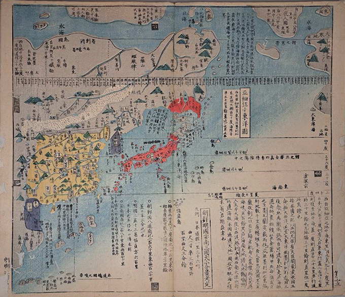
1835. Containing 13 double-page colour woodblock maps, Japanese accordion binding with paper-covered boards, title in Hiragana characters on slip affixed to cover, red seal to title page, 34.8 x 20.5cm (book), approx. 33.5 x 39cm (map). Repaired worming to margins and outer edges of maps, rubbing, creases and surface loss to covers. This Japanese historical atlas contains maps of China, tracing Chinese history through to the Qing Dynasty. It provides an overview of the “various provinces of China divided and sorted by different generations. The atlas lists not only the distance between cities in China but also the eight different seaways from Japan to China and their distances. It also has an overview of the Seven Warring States and a road map of China during the Tang dynasty.” First published in 1789, two editions of this atlas were published in 1835, with the final edition in 1857. Ref: Kazutaka Unno, Mapping Japan, 1998, ch. 11, accessed via University of Chicago Press website; nagakubosekisui.org.
Item #CL206-6
Price (AUD): $3,800.00 other currencies